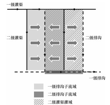
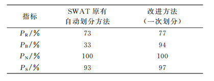
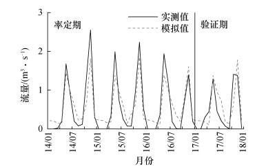
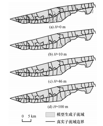
Abstract:Inaccurate subbasin definitions will affect soil and water assessment tool (SWAT) model results in plain irrigation districts. The SWAT model watershed delineation method was modified by preprocessing of digital elevation model (DEM) and joint use of automatic and pre-defined methods. This improved method was then applied to the Ninth Drainage Ditch Watershed of the Hetao Irrigation District in Inner Mongolia, China. The results show that the improved method generates specific subbasins corresponding with specific levels of the drainage ditches. This method increases the subbasin boundary agreement rate by 61% compared with the original automatic delineation method, improves the river agreement rate by 4% and improves the total watershed coverage rate by 4%. The hydrological simulation results of the improved SWAT model agree well with the measured data; thus, this method is more practical for the special management requirements of plain irrigation districts.
姜婧婧, 杜鹏飞. SWAT模型流域划分方法在平原灌区的改进及应用[J]. 清华大学学报(自然科学版), 2019, 59(10): 866-872.
JIANG Jingjing, DU Pengfei. Improvement and application of SWAT model watershed delineation method in plain irrigation districts. Journal of Tsinghua University(Science and Technology), 2019, 59(10): 866-872.
[1] KRYSANOVA V, WHITE M. Advances in water resources assessment with SWAT:An overview[J]. Hydrological Sciences Journal, 2015, 60(5):771-783. [2] 郑倩, 史海滨, 李仙岳, 等. SWAT水文模型在灌区水文和物质模拟中的研究进展[J]. 节水灌溉, 2015(9):70-73. ZHENG Q, SHI H B, LI X Y, et al. Research advance of SWAT model in hydrology and physical simulation in irrigation district[J]. Water Saving Irrigation, 2015(9):70-73. (in Chinese) [3] 李文晖, 邵东国, 徐保利, 等. 灌排系统水转化模拟模型研究[J]. 南水北调与水利科技, 2018, 16(6):130-141. LI W H, SHAO D G, XU B L, et al. Study of water transformation simulation model of irrigation and drainage system[J]. South-to-North Water Transfers and Water Science & Technology, 2018, 16(6):130-141. (in Chinese) [4] 吴用, 李畅游, 张成福, 等. 基于ArcGIS和SWAT的山区、平原区复合地貌流域划分方法研究[J]. 干旱区地理, 2016, 39(2):413-419. WU Y, LI C Y, ZHANG C F, et al. A watershed delineation method for mountains, plains complex landform area based on ArcGIS and SWAT[J]. Arid Land Geography, 2016, 39(2):413-419. (in Chinese) [5] 郑捷, 李光永, 韩振中, 等. 改进的SWAT模型在平原灌区的应用[J]. 水利学报, 2011, 42(1):88-97. ZHENG J, LI G Y, HAN Z Z, et al. Application of modified SWAT model in plain irrigation district[J]. Journal of Hydraulic Engineering, 2011, 42(1):88-97. (in Chinese) [6] 王蕾, 魏晓妹, 降亚楠, 等. 关中平原灌区SWAT模型基础数据库的构建[J]. 水电能源科学, 2017, 35(7):13-17. WANG L, WEI X M, JIANG Y N, et al. Construction of basic database for SWAT model in Guanzhong plain irrigation district[J]. Water Resources and Power, 2017, 35(7):13-17. (in Chinese) [7] 欧阳威, 黄浩波, 张璇, 等. 基于SWAT模型的平原灌区水量平衡模拟研究[J]. 灌溉排水学报, 2015, 34(1):17-22. OUYANG W, HUANG H B, ZHANG X, et al. Simulation of water balance in Hetao Irrigation District using SWAT model[J]. Journal of Irrigation and Drainage, 2015, 34(1):17-22. (in Chinese) [8] WU M, SHI P, CHEN A, et al. Impacts of DEM resolution and area threshold value uncertainty on the drainage network derived using SWAT[J]. Water SA, 2017, 43(3):450-462. [9] 马放, 姜晓峰, 王立, 等. 基于SWAT模型的亚流域划分方法研究[J]. 中国给水排水, 2015, 31(7):53-57. MA F, JIANG X F, WANG L, et al. Study on subwatershed delineation based on SWAT model[J]. China Water & Wastewater, 2015, 31(7):53-57. (in Chinese) [10] 喻晓, 马孝义, 蔡朵朵. 基于SWAT模型的合理亚流域划分和径流模拟[J]. 中国农村水利水电, 2017(11):20-25. YU X, MA X Y, CAI D D. The reasonable sub-watershed delineation and runoff simulation based on SWAT model[J]. China Rural Water and Hydropower, 2017(11):20-25. (in Chinese) [11] 陈肖敏, 郭平, 彭虹, 等. 子流域划分对SWAT模型模拟结果的影响研究[J]. 人民长江, 2016, 47(23):44-49. CHEN X M, GUO P, PENG H, et al. Influence of different sub-watershed division schemes on simulation results of SWAT model[J]. Yangtze River, 2016, 47(23):44-49. (in Chinese) [12] 王立, 李海强, 马放, 等. 基于SWAT模型的流域河网提取方法[J]. 中国给水排水, 2014, 30(13):92-95. WANG L, LI H Q, MA F, et al. Extraction method of basin drainage network based on SWAT model[J]. China Water & Wastewater, 2014, 30(13):92-95. (in Chinese) [13] 李志强, 朱超霞, 刘贵花. SWAT模型下基于DEM的水文响应单元划分:以濂水流域为例[J]. 江西水利科技, 2017, 43(6):438-442. LI Z Q, ZHU C X, LIU G H. Hydrological response unit division based on DEM in SWAT model:A case study of Lian River Basin[J]. Jiangxi Hydraulic Science & Technology, 2017, 43(6):438-442. (in Chinese) [14] LUO Y, SU B, YUAN J, et al. GIS techniques for watershed delineation of SWAT model in plain polders[J]. Procedia Environmental Sciences, 2011, 10:2050-2057. [15] 孙世明, 付丛生, 张明华. SWAT模型在平原河网区的子流域划分方法研究[J]. 中国农村水利水电, 2011(6):17-20. SUN S M, FU C S, ZHANG M H. Delineating sub-basins in flat plain areas using SWAT models[J]. China Rural Water and Hydropower, 2011(6):17-20. (in Chinese)
 2019, Vol. 59