

在全球气候变暖、城市化进程加速发展的背景下,极端降水发生频率呈上升趋势,北京、西安、郑州、上海、广州等城市先后受到暴雨洪涝灾害威胁,许多城市已呈现“暴雨必涝”的势态。城市暴雨洪涝常引发交通瘫痪、供水供电中断等次生灾害,是致灾因子风险性与承灾体脆弱性综合作用的结果,对社会经济发展、居民生命财产安全构成巨大威胁。然而,致灾因子风险性通常难以改变,于是降低承灾体脆弱性是降低灾害风险、提高抗灾能力的有效手段[1]。因此,对暴雨引发的城市洪涝灾害进行深入研究和量化评估逐渐成为人们关注的重点。
城市暴雨洪涝脆弱性(以下简称洪涝脆弱性)是对自然灾害领域中经典脆弱性理论的进一步拓展和延伸,通常以承灾体脆弱性为基础,在城市、区县、流域和栅格等特定的空间尺度下,研究灾害对生态、环境、资源、社会和经济等多方面的影响,量化城市在暴雨洪涝灾害下可能遭受的损失程度,刻画暴雨洪涝灾害的空间集聚性特征并揭示不同区域洪涝脆弱程度差异[2]。早期研究中,学者Benito等[3]、Santos等[4]、刘新立等[5]、杨佩国等[6]基于历史灾害数据,结合统计学、历史学、地质学等多学科知识分析洪涝灾害特征并进行脆弱性评估。之后, Erena等[7]、Kablan等[8]、李正兆等[9]和王成坤等[10]应用风险评估框架,选取影响洪涝脆弱性的因素构建评价指标体系,并采用数理计算等方法处理指标数据,得到洪涝脆弱性评估等级。Davis等[11]、Monteleone等[12]、代鑫等[13]以表格、曲线和曲面等形式呈现洪涝脆弱性曲线,反映洪涝灾害强度与承灾体损失程度之间的映射关系。近年来,随着评估方法与计算机技术的日益进步,地理信息系统(geographic information system, GIS)、遥感(remote sensing, RS)影像等技术越来越多地被应用于洪涝脆弱性评估,主要是以洪涝灾害时遥感图像为基础,借助ArcGIS平台提取灾区信息,并叠加承灾体信息,研究分析洪涝脆弱性风险等级。Abebe等[14]、Apreda等[15]、Chang等[16]、高超等[17]、王豫燕等[18]和陈轶等[19]结合城市自然环境、社会经济条件和综合生态响应机制间的相互作用,运用ArcGIS平台识别极端气候条件下城市洪涝脆弱性的空间分布特征,实现灾害数据获取与空间可视化表达,并针对不同脆弱性类型提出相应防范措施。
综上所述,国内外学者在城市洪涝脆弱性评估研究中已取得一定成果,但由于数据采集的局限性,此类研究多在城市宏观尺度或行政区县中尺度进行,重点衡量区域内脆弱性的总体水平,却忽略脆弱性的多维信息,无法揭示脆弱性的内在空间差异。此外,在脆弱性评估过程中,指标权重的计算往往采用单一的主观或客观计算方法,无法兼顾专家从业经验的可靠性与指标数据的客观性。
为此,本文基于脆弱性评估方法,围绕“暴露度-敏感性-应对能力”构建洪涝脆弱性评估指标体系,以洪涝风险较高的西安市为例,整合多源稠密数据,基于精细尺度栅格,揭示洪涝脆弱性空间分异格局,分析不同脆弱性等级地域分布,识别其致脆因子,绘制洪涝脆弱性空间分布图,对推进韧性城市建设、降低暴雨洪涝风险有着重要的科学意义,为实现可持续发展提供有力支持。
1 模型与计算方法
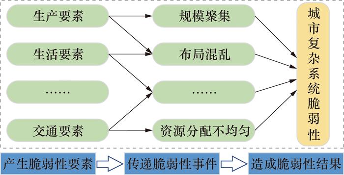
参考联合国政府间气候变化专门委员会(Intergovernmental Panel on Climate Change, IPCC)第3次评估报告[20]的概念框架,梳理国内外学者的研究成果[3-19]可知,脆弱性理论模型旨在确定脆弱性产生的根本原因,分析其形成机制中各要素间内在联系。在灾害风险管理领域,洪涝脆弱性通常包括暴露度、敏感性和应对能力3个维度[21]。从钱学森复杂系统脆弱性理论[22]出发,洪涝脆弱性是城市复杂系统内生产、生活及交通等承灾体要素暴露于灾害区域的风险程度,是暴露度、敏感性和应对能力在自然环境与人文环境影响下的整体表现[1],形成机制如图 1所示。本文围绕产生、传递、结果3个层面对洪涝脆弱性进行分析研究。
1.1 脆弱性评估模型构建
“暴露度-敏感性-应对能力”评估模型是城市脆弱性评估研究中用于评估洪涝灾害风险的一种常用模型,评估框架如图 2所示。暴露度指城市暴露于灾害风险内,对于某个特定地区,其面临的风险要素越多,则遭受灾害时损失就越多,因此该地区越脆弱[23]。敏感性反映承灾体抵御风险的能力,突出由于承灾体自身性质不同而导致面临相同灾害时存在风险差异性,即在同等洪涝灾害条件下,受灾范围的敏感性越高时承灾体的损失越大[24]。应对能力是指城市应对和适应各种灾害以及灾后重建的能力,反映城市复杂系统对灾害的认知、风险管理和应对调整,是为降低脆弱性、提升应对响应能力而采取的措施,强调减轻受灾害影响的能力和从灾害中恢复的能力[25]。暴露度和敏感性是城市洪涝脆弱性的消极被动因子,应对能力则是积极主动因子,三者共同影响洪涝脆弱性等级与洪涝灾害损失程度。随着对洪涝脆弱性评估的不断研究,结合以人为本的观念,学者们逐渐将研究重心由物理要素转向以人为核心,强调人在洪涝脆弱性形成过程中发挥的主动作用,将其作为降低脆弱性的重要手段[26]。

综上所述,本文围绕暴露度、敏感性及应对能力3个评估因子,选取年平均降雨量等9个表征指标,构建洪涝脆弱性评估指标体系,见表 1。
表 1 城市暴雨洪涝脆弱性评价指标体系 |
| 评估因子 | 表征指标 | 解释说明 | 作用方向 |
| 暴露度 | 年平均降雨量 | 降雨是城市产生洪涝灾害的直接原因,年平均降雨量可以反映区域范围内洪涝灾害的危险程度 | 正向 |
| 城市地表高程 | 地表高程可以反映区域范围内地表坡度,地表高程越小,坡度越大,降雨时越容易产生积水,造成洪涝灾害 | 负向 | |
| 积水点数量 | 洪涝灾害发生过程中,积水直接威胁城市居民的生命财产安全,积水点越多,洪涝风险越大 | 正向 | |
| 敏感性 | 人口密度 | 城市居民是洪涝灾害的直接承灾体,人口密度可表征区域内居民的密集程度 | 正向 |
| 建筑密度 | 洪涝灾害主要承灾体是城市建筑,建筑密度越大,地表不透水面积越大,灾害造成的损失也越大 | 正向 | |
| 道路密度 | 极端暴雨天气下城市道路会产生积水,造成交通拥堵,严重积水会导致大面积路面被淹没,极易引发交通事故,对城市复杂系统的正常运行造成威胁 | 正向 | |
| 应对能力 | 应急避难场所数量 | 发生洪涝灾害时,公园、绿地等应急避难场所可为城市居民提供临时住所和基础的生活保障。未发生灾害时,应急避难场所可作为灾害应急演练场所,用于增强城市居民的洪涝灾害防范意识,提升应对能力 | 负向 |
| 综合医院数量 | 综合医院的数量关系到城市居民的健康,反映城市医疗卫生水平。综合医院是现代城市可持续发展的重要保障,其数量可表征城市居民受到暴雨洪涝伤害时快速就医的可达性 | 负向 | |
| 消防救援站数量 | 消防救援站等应急救援单位能够在灾害发生时迅速出动救援,将洪涝灾害的风险和损失控制至最低,其数量可表征发生洪涝事件时城市居民得到救援的时效性 | 负向 |
1.2 脆弱性评估方法
1) 暴露度指数。
设定年平均降雨量、城市地表高程和积水点数量等指标表征暴露度因子,计算暴露度指数(E)得到
Ei表示第i个栅格的城市暴雨洪涝的暴露度指数,μij代表第j个的暴露度指标的综合权重值,Eij为第j个暴露度指标归一化的值。
2) 敏感性指数。
选取城市人口密度、建筑密度和道路密度构建敏感性因子评估指标,敏感性指数(S)可以表示为
式中:Si表示第i个栅格的敏感性指数,μij代表第j个敏感性指标的综合权重值,Sij为第j个敏感性指标归一化的值。
3) 应对能力指数。
根据城市应急资源点的空间分布数据,利用Thiessen多边形获取每个应急资源点的服务范围,计算应对能力指数(C),如图 3所示。
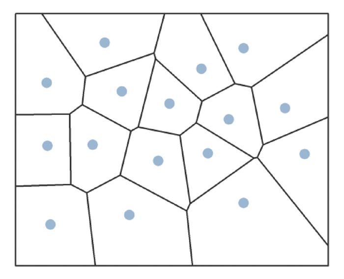
式中:μij代表第i个栅格内第j个应对能力指标的综合权重值, Ai代表第i个Thiessen多边形的面积,Cij代表第i个Thiessen多边形内第j个应对能力指标归一化的值。
4) 洪涝脆弱性指数。
基于综合指数法,根据本文界定的洪涝脆弱性内涵及评价指标体系,计算洪涝脆弱性指数(V),
式中Vi表示第i个栅格的洪涝脆弱性指数。
1.3 组合权重计算
1.3.1 改进专家打分法
本文将改进后的组合数有序加权算子引入专家打分法,改善传统方法易受专家主观偏好与认知差异影响的问题,计算得到主观权重。步骤如下[27]:
1) 邀请6名从事城市暴雨洪涝风险相关研究的专家,采用十分制对各指标的重要性进行打分,构建初始数据集P={p1, p2, …, pn}。将初始数据集从0开始重新编号并进行降序排列,得到改进数据集Q={q0, q1, …, qn-1}。
2) 计算改进数据集Q中各指标数据的加权向量 ω,其中$\sum\limits_{m=0}^{n-1} \omega_{m+1}=1$ ,n为专家数。
3) 用权重 ω对数据集Q加权,得到第j个指标的绝对权重ωj,s为评价指标个数。
4) 绝对权重ωj归一化计算得到相对权重ωj,
1.3.2 改进熵权法
改进熵权法通过优化变异系数提高信息熵度量,从而增强客观数据的变异程度。具体步骤如下[28]:
1) 通过极差标准化对原始数据进行归一化处理,消除不同指标间量级、量纲和性质的差异。其中xij为第i个评估对象的第j个指标,归一化计算公式见式(8)。对地表高程等负向指标数据归一化时,通过式(9)进行反向归一化。
式中:xij′为归一化处理后的指标数据,i=1, …, n, j=1, …, s。
2) 计算第j个指标的熵值Hj,
式中$f_{i j}=\frac{x_{i j}^{\prime}}{\sum\limits_{i=1}^n x_{i j}^{\prime}}$ 。
3) 计算第j个指标的改进熵权,
式中: $\sum\limits_{j=1}^s W_j=1, 0 \leqslant W_j \leqslant 1 ; W_j^{\prime}=\frac{1-H_j}{\sum\limits_{j=1}^s\left(1-H_j\right)}$ ;$W^{\prime \prime}{ }_j=\frac{1+\bar{H}-H_j}{\sum\limits_{k=1, H_k \neq 1}^s\left(1+\bar{H}-H_k\right)}$ 。
1.3.3 博弈论组合赋权
本文基于博弈理论,围绕Nash均衡方程优化权重计算过程,寻求主、客观两种计算方法的均衡性与一致性,减弱专家主观判断对赋权结果造成的不良影响,降低熵权法对数据关联性的依赖,同时兼顾两种方法的优点。赋权过程如下[29]:
1) 综上可得初始权重向量 uk=(uk1, uk2, …, ukt), 其中k为权重计算方法数,则向量间线性组合为
2) 通过u和uk的离差极小化,实现主、客观权重的最佳组合,优化式(12)中k个线性组合权重系数 α,得到 u中最佳组合即为组合权重,
2 实例计算
2.1 研究区域概况
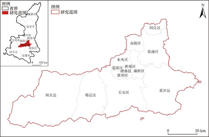
西安市位于陕西省关中平原核心位置,属暖温带半湿润大陆性季风气候。受全球气候变化、秦岭焚风效应和大气环流异常等要素综合影响,西安市频现极端降雨天气。经统计,2013—2022年西安市暴雨日为124 d,其中大暴雨日为19 d(数据来源于国家青藏高原科学数据中心)。暴雨导致城市复杂系统面临着超负荷压力,居民生命财产安全与城市健康发展遭受洪涝灾害威胁。因此,本文综合考虑城市行政区域的完整性、指标分布的聚集性和数据获取的可行性等因素,确定西安市行政区域为研究范围,如图 4所示。
2.2 数据来源与处理
本文研究数据来源如表 2所示。
表 2 洪涝脆弱性评估指标来源及权重 |
| 评估因子 | 表征指标 | 数据来源 | 指标权重 | ||
| 主观 | 客观 | 组合 | |||
| 暴露度 | 年平均降雨量 | 国家青藏高原科学数据中心 https://data.tpdc.ac.cn/ | 0.110 | 0.127 | 0.117 |
| 城市地表高程 | 中国数字高程模型(DEM) | 0.081 | 0.129 | 0.101 | |
| 积水点数量 | 西安市应急管理局 https://yjglj.xa.gov.cn/ | 0.165 | 0.045 | 0.115 | |
| 敏感性 | 人口密度 | WorldPop数据库与西安市统计年鉴 https://www.worldpop.org/ | 0.114 | 0.100 | 0.108 |
| 建筑密度、道路密度 | 开放街道地图(OSM) https://www.openstreetmap.org/ | 0.089 0.141 | 0.109 0.112 | 0.098 0.129 | |
| 应对能力 | 应急避难场所数量 | 高德地图数据 http://www.amap.com/ | 0.076 | 0.126 | 0.097 |
| 综合医院数量 | 0.099 | 0.128 | 0.111 | ||
| 消防救援站数量 | 0.125 | 0.124 | 0.125 | ||
1) 暴露度评估所需数据:西安市年平均降雨量来源于国家青藏高原科学数据中心,地表高程采用中国数字高程模型(digital elevation model, DEM)数据计算得到,积水点数量来源于西安市应急管理局。
2) 敏感性评估所需数据:人口密度数据来源于WorldPop数据库与西安市统计年鉴,建筑密度和道路密度数据来源于开放街道地图(open street map, OSM)。
3) 应对能力评估所需数据依据高德数据分类体系直接爬取得到:应急避难场所由城市公园及绿地组成,综合医院指包含多学科、多层次、多专业诊疗能力的医院,消防救援站包括微型站、一级站和二级站等不同等级的消防应急单位。利用ArcGIS平台对研究区进行1 km×1 km栅格化,共计10 289个栅格,同时对栅格数据进行矢量转换,归一化至[0, 1]。采用自然断点法分为5个等级,得到各指标在1 km栅格尺度下的空间分布图,如图 5所示。
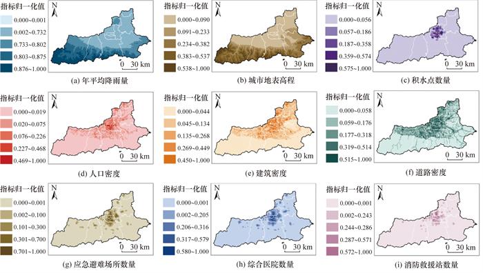
由表 2可知,主观权重计算由于专家的从业经验与个人偏好不同,因此各指标得到截然不同的权重值,积水点数量、道路密度和消防救援站数量等表征指标的主观权重值最高,分别为0.165、0.141和0.125。客观权重计算基于多源数据处理,在1 km×1 km栅格的精细尺度下,得到的客观权重值相对接近,其中年平均降雨量、城市地表高程和综合医院数量等表征指标的客观权重值较高,分别为0.127、0.129和0.128。于是,本文借助博弈论方法,将主、客观权重值优化组合,既保留专家打分法的权威性,又结合指标数据的客观性,最终得到更加科学合理的组合权重值。表征指标年平均降雨量、道路密度和消防救援站数量的组合权重值最高,分别为0.117、0.129和0.125。
由图 5可见,西安市南部、西部多为山区,尽管城区年平均降雨量低于山区,但由于城区建筑道路密集,雨水不易渗流至地下,导致城区内积水点较多,同时中心城区人口密度较大,因此配套应急避难场所、综合医院及消防救援站等设施较为完善。
3 结果与分析
3.1 脆弱性空间分布特征分析
综上所述,通过式(1)—(4)计算得到每个栅格的洪涝暴露度指数、敏感性指数、应对能力指数和综合脆弱性指数。采用自然断点划分为由低到高的5个等级,并借助ArcGIS平台将各指数的空间分布进行可视化,结果如图 6所示。
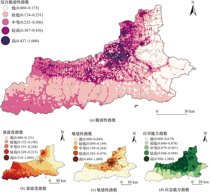
由图 6a可知,西安市暴雨洪涝脆弱性指数从低到高各等级的面积占比分别为18.66%、38.40%、29.34%、10.54%、3.06%。高脆弱性地区主要呈片状集聚在城区中部以北的老城区,此类区域大多为复杂功能用地,下垫面由硬质铺砖组成,建设密度较大,开发强度较高,人口较为密集。低和较低脆弱性地区主要集聚在长安区、鄠邑区、临潼区、阎良区、周至县和蓝田县,此类区域大多由林地与耕地组成,生态承载力较高。
由图 6b、6c、6d可见,暴露度指数从低到高5个等级的面积占比分别为17.23%、28.81%、26.88%、21.59%、5.49%;低和较低等级区域主要分布在西安市城六区(新城区、碑林区、莲湖区、未央区、雁塔区、灞桥区)和长安区、临潼区、阎良区和蓝田县,中和较高等级区域呈连续切片分布在鄠邑区、高陵区和周至县,高等级暴露度区域则少数零星分布在城六区中。敏感性指数从低到高5个等级的面积占比分别为50.24%、24.12%、14.73%、7.65%、3.26%;低等级区域大面积分布在城市南部山区部分,如临潼区、长安区、鄠邑区、周至县南部和蓝田县,较低和中等级区域则呈带状分布在城六区以外的地区,如临潼区、长安区、鄠邑区、周至县北部及高陵区和阎良区,高等级区域则呈片状分布在城六区。应对能力指数从低到高5个等级的面积占比分别为13.39%、20.87%、13.01%、33.86%、18.87%;高等级区域占据了西安市全部的中心城区,较高等级区域占比最大,分布在西安市中部以北除高等级区域外的全部地区,中和较高等级区域则分布在城市南部,低等级区域全部在城市西部的周至县;可以看出,城市中部与东西部地区应对能力指数差异较为显著,南部与北部地区差异也较为显著。
3.2 脆弱性空间集聚特征分析
采用GeoDa软件分别计算全局Moran's I指数与局部空间关联指数(local indicators of spatial association, LISA),用于探测城市暴雨洪涝脆弱性的全局空间自相关特征以及局部空间自相关特征,结果如图 7所示。在聚类分析中:H(high)代表高聚类,L(low)代表低聚类。
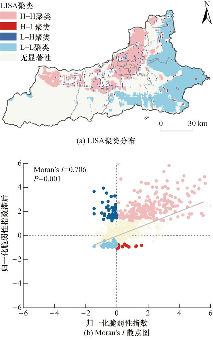
由图 7a可知,城市暴雨洪涝脆弱性的LISA聚类中H-H聚类、L-L聚类较多,其中H-H聚类呈斑块状主要分布在新城区、碑林区、莲湖区、雁塔区、未央区和高陵区,L-L聚类呈片状主要集聚在临潼区、长安区和蓝田县。
由图 7b可知,城市暴雨洪涝脆弱性的Moran's I指数为0.706 (P=0.001),表明城市暴雨洪涝脆弱性具有空间集聚特征,呈现显著的空间正相关性;同时,从侧面反映城市暴雨洪涝脆弱性问题不可忽视,若不加以管控,高脆弱性比例会由于集聚效应进一步增加。其主要原因有两点:1) 城市建成区存在明显的空间积聚性,城区内建有大量建筑与道路,导致地面不透水性增加;2) 城区内建有丰富的教育、医疗和应急资源,由此导致大量人口涌入城区内,造成人口聚集,使得暴雨洪涝脆弱性升高。
3.3 脆弱性致脆类型分析
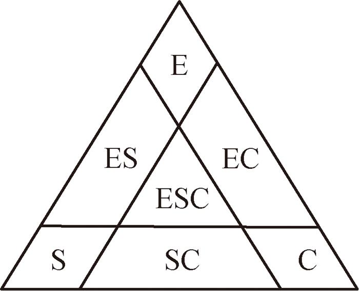
表 3 不同脆弱性类型的面积比例 |
| 脆弱性类型 | 栅格数量 | 所占面积 | 占比 | ||
| 个 | km2 | % | |||
| 弱综合脆弱型(O) | 31 | 30.45 | 0.30 | ||
| 暴露度致脆型(E) | 18 | 17.68 | 0.17 | ||
| 敏感性致脆型(S) | 305 | 299.58 | 2.96 | ||
| 应对能力不足致脆型(C) | 3233 | 3 175.49 | 31.42 | ||
| 暴露-敏感致脆型(ES) | 124 | 121.79 | 1.21 | ||
| 暴露-应对能力不足致脆型(EC) | 4721 | 4 637.03 | 45.88 | ||
| 敏感-应对能力不足致脆型(SC) | 1168 | 1 147.23 | 11.35 | ||
| 强综合脆弱型(ESC) | 689 | 676.75 | 6.71 |
由表 3可知,不同脆弱性类型的面积占比由大到小顺序为EC (45.88%)>C (31.42%)>SC (11.35%)>ESC (6.71%)>S (2.96%)>ES (1.21%)> O (0.30%)>E (0.17%)。EC型脆弱性面积最大为4 637.03 km2,E型脆弱性面积最小为17.68 km2。其他脆弱性类型面积由低到高依次为3 175.49 km2(C)、1 147.23 km2(SC)、676.75 km2(ESC)、299.58 km2(S)、121.79 km2(ES)、30.45 km2(O)。借用ArcGIS平台将不同脆弱性类型的空间分布可视化,结果如图 9所示。
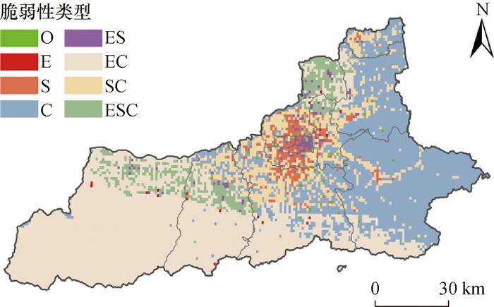
表 4 各类脆弱性不同等级的面积占比 |
| 脆弱性类型 | 各类脆弱性不同等级的面积占比/% | ||||
| 低 | 较低 | 中 | 较高 | 高 | |
| 弱综合脆弱型(O) | 0.94 | 0.33 | 0.00 | 0.00 | 0.00 |
| 暴露度致脆型(E) | 0.21 | 0.18 | 0.20 | 0.09 | 0.00 |
| 敏感性致脆型(S) | 0.83 | 1.27 | 2.95 | 9.96 | 13.29 |
| 应对能力不足致脆型(C) | 97.97 | 29.44 | 6.26 | 0.00 | 0.00 |
| 暴露-敏感致脆型(ES) | 0.05 | 0.03 | 0.60 | 3.23 | 21.84 |
| 暴露-应对能力不足致脆型(EC) | 0.00 | 67.61 | 66.64 | 3.41 | 0.32 |
| 敏感-应对能力不足致脆型(SC) | 0.00 | 1.14 | 19.11 | 41.24 | 31.33 |
| 强综合脆弱型(ESC) | 0.00 | 0.00 | 4.24 | 42.07 | 33.23 |
| 合计 | 100.00 | 100.00 | 100.00 | 100.00 | 100.00 |
由表 4可知,低等级脆弱性区域中,主要类型为C型,占比97.00%以上。较低等级脆弱性区域中,EC型和C型占比较高,分别为67.61%和29.44%,其他类型则不足3%。较高等级和高等级区域内脆弱性类型相似,主要类型为SC型和ESC型。在较高等级区域内,SC和ESC类型分别占比41.24%和42.07%;高等级区域中,SC型和ESC类型占比稍弱于较高等级,分别为31.33%和32.23%。与其他等级不同的是,中等级区域内包含了除O型外的所有脆弱性类型,E型、S型、C型、ES型、EC型、SC型、ESC型面积占比分别为0.20%、2.95%、6.26%、0.60%、66.64%、19.11%、4.24%。总体来看,低和较低等级区域主要脆弱性类型为C型和EC型,中等级区域EC型占据大部分比例,而较高和高等级区域脆弱性类型则以SC型和ESC型居多。
4 结论
本文围绕“暴露度、敏感性、应对能力”评估因子建立暴雨洪涝脆弱性评估多层次指标体系,基于博弈论组合主客观权重计算方法,构建脆弱性评估模型。以西安市为例,基于多源数据对各级指标进行测度。借助ArcGIS平台实现洪涝脆弱性的空间分布可视化,利用LISA聚类研究洪涝脆弱性集聚特征差异,识别不同洪涝脆弱性类型并解析其致脆因子,以此指导针对性暴雨洪涝灾害防范策略的制定。
研究结果表明:1) 基于博弈论的组合权重计算方法的脆弱性评估模型可减小主观权重计算的局限性,弥补客观权重计算的不足,兼顾主客观权重优点,保障脆弱性评估结果的可靠性。2) 面临暴雨天气时,该市洪涝灾害的暴露度、敏感性和应对能力表现出一定的空间集聚特征,同时洪涝脆弱性呈现显著空间正相关性,且空间集聚性较强,若不加以管控,高脆弱性区域会由于集聚效应进一步增加。3) 该市整体洪涝脆弱性等级偏低,中及以下等级洪涝脆弱性面积占全市面积的86.40%。但是,城市中心区域内洪涝脆弱性等级较高,以积水严重的道路交叉口、下穿隧道涵洞等地势低洼处为主,其洪涝脆弱类型主要为敏感性致脆型(S) 和暴露-敏感致脆型(ES)。
