Hydraulic Engineering

Intermittent river morphology extraction method based on multisource remote sensing and river characteristics: A case study in Wuding River Basin

  • Xuanwei XING 1, 2 ,
  • Yuan XUE 1, 2 ,
  • Yongxian ZHANG 1, 2 ,
  • Chao QIN 3 ,
  • Dan LI 4 ,
  • Mengzhen XU , 1, 2, *
Expand
  • 1. Department of Hydraulic Engineering, Tsinghua University, Beijing 100084, China
  • 2. State Key Laboratory of Hydroscience and Engineering, Tsinghua University, Beijing 100084, China
  • 3. State Key Laboratory of Loess and Quaternary Geology, Institute of Earth Environment, Chinese Academy ofSciences, Xi'an 710061, China
  • 4. Emergency Science Research Academy, ChineseInstitute of Coal Science, Beijing 100013, China

Received date: 2024-07-11

  Online published: 2025-07-24

Copyright

All rights reserved. Unauthorized reproduction is prohibited.

Abstract

Objective: Intermittent rivers, distinguished by sporadic flow cessation, account for more than half of the global river network and are particularly prevalent in semiarid and arid zones, such as the northwest region of China. These watercourses are pivotal in hydrological modeling, sediment transport simulations, and evaluation of riverine ecosystems. Nevertheless, precise extraction of riverbed and cross-sectional data for intermittent rivers during low-flow periods poses a formidable challenge, largely due to the paucity of data and the constraints inherent in conventional measurement techniques. The current methodologies, including digital elevation models (DEM) and empirical equations, fail to deliver continuous and accurate data on river morphology. This study tackles these challenges by introducing a graphics processing unit (GPU)-accelerated random forest (GRF)-convolutional neural network (CNN) algorithm, referred to as the GRF-CNN algorithm, that harnesses multisource remote sensing information and integrates soil moisture downscaling to delineate riverbed characteristics under bankfull and dry states. Methods: This research centers on the Wuding River Basin, a typical intermittent river system located on the Loess Plateau of China. This study develops and validates the GRF-CNN algorithm via integration and optimization of advanced techniques for river morphology extraction. Multisource remote sensing datasets, such as thermal infrared data from the Landsat-8 and ZY1-02E satellites and soil moisture data from the soil moisture active passive (SMAP) satellite and the Sentinel-1 synthetic aperture radar, are used for comprehensive surface and subsurface analyses. Building on the parallel random forest-artificial neural network (PRF-CNN) framework, the GRF-CNN algorithm incorporates CNN modules to enhance the downscaling of thermal infrared data and improve soil moisture inversion. A hybrid statistical-physical model, combining the water cloud model, Dubois model, and advanced integral equation model, along with the deep supervised neural network, is employed to increase the spatial resolution of soil moisture data to 10 m. Specific soil moisture thresholds for different river levels (4th-7th order) are established to accurately extract riverbeds and cross-sectional boundaries during dry seasons. The algorithm's performance is confirmed via hydrological station measurements and high-resolution satellite images. Results: The results demonstrate that the downscaled soil moisture data achieve an R2 of 0.81 and a root mean square error of < 0.059 m3/m3, outperforming conventional soil moisture products. The GRF-CNN algorithm achieves 95.7% accuracy for bankfull river surfaces and 90.3% for dry season riverbeds, with a 27.3% improvement in accuracy of generalized cross-sectional bottom width extraction versus the PRF-ANN algorithm. Furthermore, GRF-CNN surpasses widely recognized machine learning models, including DiCNN-4, Bi-LSTM, and Transformer-based methods, by a margin of at least 10% in terms of Kappa coefficient, overall accuracy, classification accuracy, F1 score, and recall, particularly in the extraction of intermittent river features. Conclusions: This study underscores the potential of integrating multisource remote sensing data with sophisticated machine learning algorithms to tackle the challenges associated with the extraction of river morphology in intermittent river systems. The GRF-CNN algorithm offers a scalable and precise solution for reconstructing river boundaries and estimating cross-sectional parameters in data-scarce regions. Moreover, it illustrates the benefits of incorporating soil moisture dynamics into riverbed morphology extraction processes. We believe the results have far-reaching implications for hydrological modeling, sediment transport studies, and developing digital twin watersheds for resource management and ecological restoration in arid and semiarid areas. By addressing the gap in river morphology data extraction, this study provides substantial technical and data support for increasing the accuracy of hydrological simulations and advancing sustainable watershed management strategies.

Cite this article

Xuanwei XING , Yuan XUE , Yongxian ZHANG , Chao QIN , Dan LI , Mengzhen XU . Intermittent river morphology extraction method based on multisource remote sensing and river characteristics: A case study in Wuding River Basin[J]. Journal of Tsinghua University(Science and Technology), 2025 , 65(8) : 1569 -1582 . DOI: 10.16511/j.cnki.qhdxxb.2025.22.010

河流边界条件是开展河流地貌演变、全物质通量和流域水沙模拟等研究的重要参数,包括河流表面信息、河流断面形态等[1]。其中,河流断面形态是最基础却最难获取的河流边界条件之一[2]。获取河流断面形态的常用方法包括:现场量测[3]、基于经验公式或水文模型结合部分实测资料模拟[4],以及通过数字高程模型(digital elevation model,DEM)近似提取[5]。这些方法均较为依赖实测数据以校准模型、验证结果和提高精度。间歇性河流是因季节性降水、地下水补给等因素,在特定时期出现干涸或断流的河流[6],全球河流中超50%为间歇性河流[7]。这类河流在枯水期,部分河床裸露,通过传统方法提取的河流信息极为破碎,导致河流边界提取不完整、失真,水系提取结果连通性较差[8]。中国间歇性河流分布广泛,主要位于西北干旱半干旱区域[9-10]。这些河流的流量随季节变化显著,分布广泛的沟道和小型河道频繁干涸,无法通过卫星遥感等方法直接观测,致使河流边界条件难以准确提取。高精度、高效获取间歇性河流的边界条件,对于水资源动态监测及数字孪生流域建设,具有重要意义。然而,受限于现场量测成本、有限的水文站观测数据丰度及开源DEM数据精度,间歇性河流断面形态等几何信息仍极为匮乏,严重制约了流域水沙模拟、水文过程和河流物质通量等研究,阻碍了缺资料地区数字孪生流域的低成本、高效率建设。
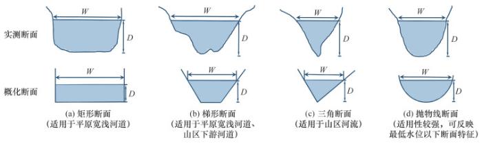
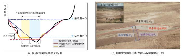
随着“天-空-地”多源对地观测网络不断完善[11],利用多源遥感数据提取河流断面形态已得到广泛关注[12]。现有研究多参考水文站等间距测绘断面形态或常用分布式水文模型概化河道断面的思路,基于一定假设将河流断面概化为简单几何形状[13](图 1),减少获取断面形态所需的数据量,进而利用多源遥感数据获取关键参数,提取河流断面[14-15]。因一般梯形断面数据需求量少、可推广性强,成为常用的断面概化形状(图 2a)。平滩期与枯水期河流表面信息是关键参数[16]。现有研究多基于水体区别于其他地物的特征提取河流表面信息[17-18],但该方法应用在间歇性河流表面信息提取时结果通常是破碎的,噪声广布,难以获取完整的河流表面信息(图 2b)[19]。因此,此方法得到的概化断面不能较好地反映真实断面形态。
图 1 常见河流概化断面形状示意图[13]
图 2 间歇性河流过水断面及湿润河床示意
河流消落带是指河流水位季节性变化过程中暴露或淹没的床面沿岸地带。针对河流消落带土壤水分特性的研究表明,消落带土壤水分会与断面其他位置呈现显著差异[20]。因此,引入土壤水分作为识别河流表面信息的河流特征,能够根据消落带土壤水分条件,将间歇性河流枯水期有限的水体表面扩展为更接近真实情况的河流床面(图 2b),从而提升河流表面信息提取的完整程度,获取更准确的概化河流断面形态。但常用的土壤水分产品空间分辨率较低,多为km级[21-22],难以满足提取细小河流及完整河网的需求,因此应对现有土壤水分产品降尺度,提升其空间分辨率。
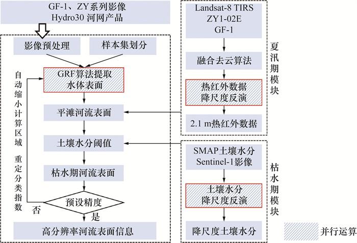
本研究针对枯水期河流表面及床面信息难以提取的问题,以广泛分布于中国内陆区域的间歇性河流为研究对象,选取黄河中游一级支流无定河流域为研究区域。通过优化夏汛期热红外数据降尺度模块,提取平滩期河流表面信息以约束枯水期水体提取范围。建立土壤水分反演算法,考虑河流消落带特征,确定枯水期床面范围,最终构建可综合考虑河流季节性特征的GPU并行随机森林-卷积神经网络(GPU-paralleled random forest-convolutional neural network,GRF-CNN)河流表面信息提取算法。本研究证明了利用土壤水分提取缺资料地区河流概化断面关键参数的可行性,通过捕捉间歇性河流过水范围,提升了河流边界提取的完整性,为探究基于多源遥感获取完整河流边界条件、提升水文过程模拟效果等研究提供技术及数据支撑。

1 研究方法及模型介绍

本研究在并行随机森林-人工神经网络(parallel random forest-artificial neural network,PRF-ANN)算法基础上[16, 23],构建GRF-CNN算法。通过优化云量覆盖情况的判别,提高夏汛期模块的多云影像识别效果。引入土壤水分降尺度反演模型,设定土壤水分阈值来确定床面提取范围。改进后的算法采用GPU集群加速运行,整体提取流程由GPU并行随机森林算法(GPU-paralleled random forest, GRF)、夏汛期热红外数据降尺度反演、枯水期土壤水分降尺度反演3大部分组成。GRF-CNN算法的技术路线见图 3,图中红色框线表示关键步骤。
图 3 河流表面信息提取算法GRF-CNN的技术路线

1.1 GRF算法基本框架

GRF算法模块需要导入适用于间歇性河流的水体指数库,该指数库源于PRF-ANN算法的指数库[16]。GRF的提取参数包括水体指数和植被指数、光学波段、热红外数据及纹理指数共计64个。本研究结合土地利用类型数据,选取尽可能包含流域内所有地物的有限区域开展预实验,自动筛选Gini指数[24]排序显著靠前、对区分地物的贡献度较高的水体指数,基于河流几何特征、热效应、光谱特性、纹理指数等河流全特征,提取河流表面信息。GRF算法建立了基于河流级别的多尺度奇点指数(river-level-based multi-scale singularity index, RMSI)运算模块[25],计算河流的曲线结构;引入面向河流对象的几何特征,通过计算RMSI提取流域内不同尺度的河流。GRF算法提取流程结束后,将自动检验Kappa系数,若满足预设精度则输出至下一模块,反之将循环原程序提取参数(本步骤可以调整预设精度)。

1.2 夏汛期模块改进

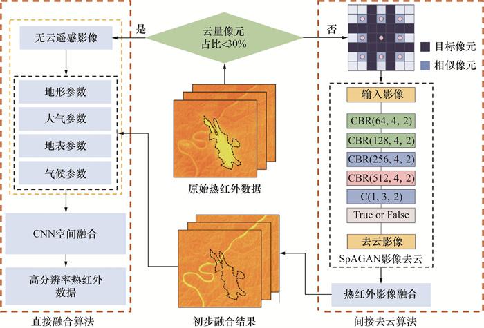
反映地表温度的热红外数据,可用于夏季区分河流及其他地物,提升山区河流提取的精度。早期PRF-ANN算法应用极限学习机(extreme learning machine,ELM)、反向传播人工神经网络(back propagation-artificial neural network, BP-ANN)等算法实现河网缓冲区内100 m分辨率Landsat-8热红外数据降尺度至2.1 m,但同时暴露了算法的不足,包括:1) 降尺度比例过大导致边缘失真;2) 单层隐藏神经元算法反演能力有限,需要强监督学习。本研究在原算法基础上进行改进,应用卷积神经网络(convolutional neural network, CNN)[26],基于Landsat-8热红外影像和国产15 m分辨率的ZY1-02E高分辨率热红外卫星影像,完成从数据源到降尺度算法的双升级,实现热红外数据的更高精度、更大范围空间降尺度。更新后的热红外数据降尺度方法,应用了包括地形、大气、地表和气候参数在内的4类参数,如坡度、亮温及水体指数等。具体流程为:1) 通过对预处理后的遥感影像进行晴空比例判断,确定是否适用基于CNN的降尺度反演方法。本研究中,晴空比例大于70%的影像将直接使用CNN算法降尺度。对于晴空比例小于70%的影像,采用间接去云算法,利用自适应对抗神经网络(shortest path graph attention network,SpAGAN)[27]的空间注意力机制,生成云层分布图,指导后续去云操作。2) 将去云后的影像输入CNN算法中,获取热红外数据降尺度反演结果。3) 基于原位数据、空间分布特征对比及时序分析等方法,评估热红外数据降尺度反演结果。夏汛期模块详细流程见图 4。图中CBR为卷积模块结构,即卷积层(convolutional layer)、批归一化层(batch normalization layer)、激活函数层(ReLU或其他激活函数)的缩写。
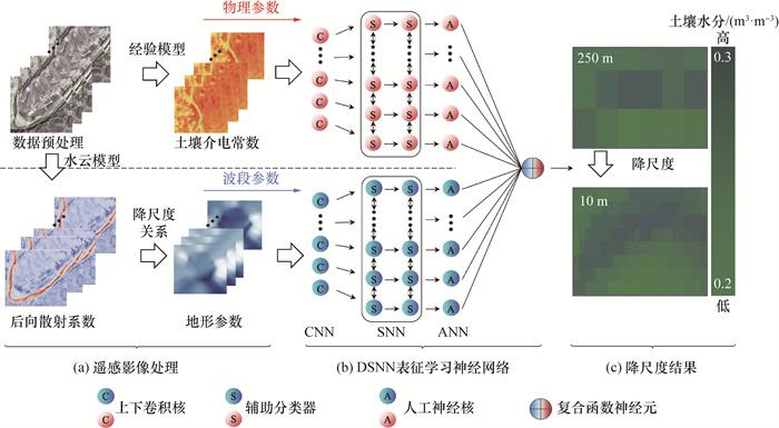
图 4 夏汛期降尺度反演热红外数据流程

1.3 枯水期土壤水分降尺度反演

本研究基于物理机理,耦合经验性统计和机器学习算法[28],建立极化合成孔径雷达(synthetic aperture radar,SAR)数据的土壤水分降尺度流程,选取土壤湿度主被动探测卫星(soil moisture active passive,SMAP)生产的全球土壤水分输出数据,其空间分辨率为9 km,时间分辨率为1 d [29]。使用Sentinel-1C SAR数据,主要采用VV波段,即垂直发射和接收雷达信号的波段。植被层对电磁波散射和吸收的影响较小,更适用于土壤水分反演[30]。利用谷歌地图引擎(Google Earth Engine,GEE)对Sentinel-1影像进行预处理,主要包括以下步骤:利用轨道文件更新轨道元数据、消除边界噪声、消除热噪声、辐射测量校准、正射校正。本研究以高分一号(Gaofen-1,GF-1)卫星影像作为光学影像数据,利用2 m多光谱影像中的近红外波段和绿光波段计算归一化水体指数(normalized difference water index,NDWI),反演植被水分。水云模型作为提取裸土后向散射系数最常用的模型,在土壤水分提取的相关研究中已有广泛应用[31]。Dubois模型一般用来提取土壤介电常数[32],可较好地反映土壤水分特性。Dubois模型配合积分方程模型(advanced integral equation model,AIEM)得到的地表粗糙度指标[33],能够构建土壤水分降尺度关系。本研究将基于地表热红外数据反演得到的数据,采用水云模型、Dubois和AIEM模型,结合表征学习神经网络(data-shifting neural network,DSNN)[34],构建降尺度反演关系。
极化土壤水分的反演研究通常基于雷达后向散射系数与土壤水分之间的物理机理建立反演模型[35]。但考虑到植被对电磁波段的影响[36],为了有效减小这种影响,本研究引入水云模型,将植被覆盖区域的后向散射系数定义为植被自身反射微波得到的体散射和经过二次反射后的地表散射之和,其物理关系为:
$\left\{\begin{array}{l}\sigma_{\mathrm{can}}^0(\theta)=\sigma_{\mathrm{veg}}^0(\theta)+\gamma^2(\theta) \cdot \sigma_{\mathrm{soil}}^0(\theta), \\\sigma_{\mathrm{veg}}^0(\theta)=A \cdot m_{\mathrm{veg}} \cdot \cos \theta \cdot\left(1-\gamma^2(\theta)\right), \\\gamma^2(\theta)=\exp \left(-2 \cdot B \cdot m_{\mathrm{veg}} \cdot \sec \theta\right) .\end{array}\right.$
其中:σcan0(θ)、σsoil0(θ)、σveg0(θ)分别为草地、裸土和植被的后向散射系数,AB为经验系数,mveg为植被水分,θ为微波入射角,γ2(θ)为二次衰减因子[37]
考虑到土壤水分能够反映土壤介电常数,可以利用土壤介电常数反演土壤水分。本研究基于Dubois半经验模型,建立土壤介电常数和裸土后向散射系数之间的联系:
$\left\{\begin{aligned}\sigma_{\mathrm{hh}}^0 & =10^{-2.75} \frac{\cos ^{1.5} \theta}{\sin ^5 \theta} \times 10^{0.03 \varepsilon_{\mathrm{r}} \tan \theta} . \\& (k \cdot s \cdot \sin \theta)^{1.4} \lambda^{0.7} , \\\sigma_{\mathrm{vv}}^0 & =10^{-2.35} \frac{\cos ^3 \theta}{\sin ^3 \theta} \times 10^{0.05 \varepsilon_{\mathrm{r}} \tan \theta} . \\& (k \cdot s \cdot \sin \theta)^{1.1} \lambda^{0.7} . \end{aligned}\right.$
其中:σhh0σvv0分别为HH和VV波段的裸土散射后向散射系数,k为入射波波数,λ为微波波长,s为地表参数,εr为土壤介电常数[38]
AIEM模型基于积分方程,考虑了地表粗糙度的统计特性,可以模拟不同类型的地表(如裸土、沙地、植被等)对电磁波的散射特性[39]。通过将模拟的雷达后向散射系数与实际SAR数据相比较,可以反演出地表粗糙度等参数。本研究使用Kirchhoff近似求解积分方程,表达式为[40]
$\begin{gathered}S_{\mathrm{GO}}\left(\theta_{\mathrm{i}}, \phi_{\mathrm{i}}, \theta_{\mathrm{s}}, \phi_{\mathrm{s}}\right)= \\\left|\frac{2 \pi}{\lambda} \frac{\cos \theta_{\mathrm{i}}+\cos \theta_{\mathrm{s}}}{\cos \theta_{\mathrm{i}} \cos \theta_{\mathrm{s}}}\right|^2 P_{\mathrm{inc}}\left(\theta_{\mathrm{i}}, \phi_{\mathrm{i}}\right) P_{\mathrm{sur}}\left(\theta_{\mathrm{s}}, \phi_{\mathrm{s}}\right) .\end{gathered}$
其中:SGO是几何光学散射系数,θiϕi是入射角和方位角,θsϕs分别是散射角和方位角,PincPsur分别是入射极化波和表面极化波。
DSNN模型是一种深度学习模型,其结构包括输入层、隐含层、深度监督路径及输出层[34]。本研究在训练过程中引入水体指数库的监督信息,以提高网络的训练效率和性能。隐含层的输出模型表达式为
$h_i=f\left(\sum\limits_{j=1}^n w_{i j} x_j+b_i\right) .$
其中:hi是第i个神经元的输出函数,f是激活函数,wij是连接第j个输入特征和第i个神经元的权重,xj是第j个输入特征,bi是第i个神经元的偏置。
本研究经过训练选取的最优激活函数为三角函数,神经元数目i=6。为了处理不同数据源之间的时空分辨率差异,本研究采用分步降尺度方法[41]。详细流程见图 5
图 5 枯水期降尺度反演河道范围土壤水分流程

2 模型验证及结果分析

2.1 研究区域及研究数据

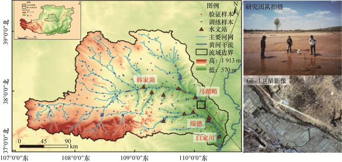
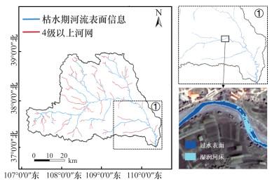
本研究的研究区域为黄河一级支流无定河流域。无定河干流全长491.2 km,主河道平均纵比降1.97%,流域面积30 261 km2,流域内分布有9座水文站[42]。无定河流域地处半湿润、半干旱地区交界带,属于温带大陆性季风气候,雨热同期[43]。流域径流量季节性变化显著,支流断流期较长,约60%的径流量发生在汛期(7—9月)[44],无定河是典型的间歇性河流。流域内河流消落带分布明显,作为陕北地区直接汇入黄河的最大支流,无定河流域输沙量大,水土流失较为严重。根据地貌类型和水土流失特点,无定河流域可分为河源梁涧型、风沙区和黄土丘陵沟壑区3种类型,这些类型广泛代表了中国西北半干旱区域的地理特征。根据清华大学Hydro30全球河网平台[45],无定河流域被划分为7级河网,其中4级及以上河流断面可按照一般梯形概化条件处理[46]图 6展示了无定河流域地理概况、河网水系及水文站分布。
图 6 无定河流域概况

2.1.1 无定河流域水文资料

平滩流量及其对应的水位与河宽是反映河槽形态特征和过流能力的指标。这些平滩特征值通常需要通过水文站实测断面来获取,但相关资料往往较为匮乏。为了利用遥感卫星获取平滩期和枯水期的河流表面信息,需确定相应的流量及其出现日期。本研究使用的水文资料来自《中华人民共和国水文年鉴黄河流域水文资料》,选取无定河流域出口水文站白家川站及3个主要子流域控制站(绥德站(大理河)、马湖峪站(马湖峪河)及韩家峁站(海流兔河))具备大断面资料的1984—2020年的逐日径流量、水位及场次洪水数据。参考山区河流平滩流量估算方法[47],本研究利用实测大断面的滩-槽结构,确定了绥德站、韩家峁站的平滩水位及对应的平滩流量;对于其他无明显滩-槽结构的水文站断面,采用Mann-Kendall(MK)方法检验各断面水文资料一致性[16, 48],确定2012—2020年为水文一致年。绘制各场次洪水洪峰流量的Pearson-Ⅲ曲线[49],查得重现期为1.5 a左右的洪峰流量,即为断面平滩流量。主要数据源GF-1卫星影像自2013年可供检索(www.data.cresda.cn),只有2016—2020年发生了平滩流量。无定河流域代表性水文站的平滩及枯水期流量影像日期见表 1
表 1 平滩及枯水期流量GF-1遥感影像日期列表
流量类型 站点名称 平滩流量估算方法 平滩流量/ (m3·s-1) 平滩流量发生时间 日均流量/ (m3·s-1) 景序列号
平滩流量 白家川站 洪水频率法 170 2016-08-21 200 2748340
2018-09-29 163 5581802
2018-08-07 174 6728462
2020-09-15 176 517300
绥德站 断面法 120 2018-08-15 138 5410076
2019-08-07 122 6728462
马湖峪站 洪水频率法 30 2019-08-07 32.3 6728566
韩家峁站 断面法 3.9 2018-09-07 3.89 171160
枯水流量 白家川站 2017-07-10 2.26 3859683
绥德站 2019-06-08 0.26 293193
马湖峪站 2019-07-10 0.20 309017
韩家峁站 2020-05-18 0.56 452332

2.1.2 卫星影像数据

本研究使用的多源遥感影像数据来源包括应用于河流表面信息提取的国产GF-1卫星、GF-2卫星、ZY-1卫星、ZY-3 03卫星及Sentinel-2卫星,应用于地表热红外数据降尺度反演的Landsat-8(TIRS)卫星及ZY1-02E卫星,应用于土壤水分降尺度反演的SMAP卫星、Sentinel-1卫星。

2.1.3 河网缓冲区

研究区内河流普遍细小,提取河流表面信息时易产生大量噪声[16],可采用传统河网构建缓冲区去噪[50-51],以提升提取精度。通过清华大学Hydro30全球河网平台与Google Earth影像,估计各级别河流偏移距离,配合水文资料确定历史最大河宽,综合获得河网缓冲区半径,建立河网缓冲区。统计得到无定河流域2012—2020年各子流域出口宽度上限为1~1.6 km。综合考虑子流域控制水文站大断面,将缓冲区半径设置为4级以下150 m、5~6级300 m、7级干流500 m, 建立河网缓冲区。

2.1.4 土地利用类型数据

准确提取河流表面信息依赖于精确的机器学习样本及合适的分类参数。本研究基于Dynamic World 10 m分辨率全球土地利用类型[52]及中国首套1 m分辨率的全国土地覆盖数据集SinoLC-1[53],完成了样本采集及分类指数的选取。研究区域训练样本及验证样本分布见图 6

2.2 平滩期河流表面信息提取

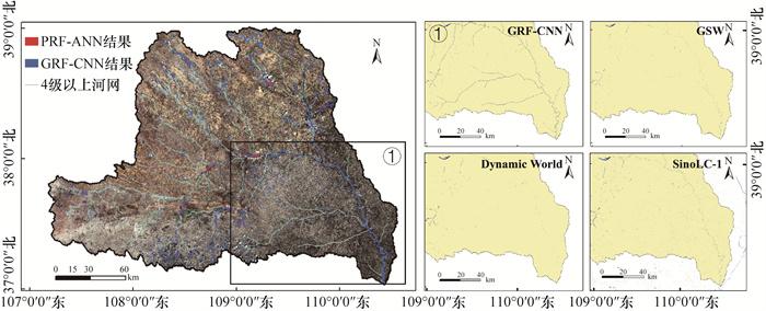
GRF-CNN算法提取平滩期河流表面信息时,校验Kappa系数预设为0.8。经交叉验证得到,CNN完成10次迭代处理后热红外数据降尺度反演结果拟合度R2为0.89,均方根误差(root mean square error,RMSE)为0.84 K,低于常用TIRS亮温误差参考标准(1~2 K)[54],结果可靠。基于夏汛期热红外数据降尺度反演结果,GRF-CNN提取的无定河流域平滩期河流表面信息,并经河网缓冲区约束及后处理的结果见图 7。平滩期河流表面信息提取精度为95.7%,Kappa系数为0.93。对比改进前的PRF-ANN算法,本方法在平滩期河流表面信息提取上精度更高,抗地物干扰能力更强。与目前受认可度较高的遥感水体产品Dynamic World、全球地表水覆盖数据集(global surface water,GSW)[55]及SinoLC-1数据集相比(图 7),GRF-CNN提取的平滩期河流表面信息完整度更优。此结果将作为枯水期河流表面信息提取的约束范围。
图 7 无定河流域平滩期河流表面信息提取结果

2.3 土壤水分降尺度反演及精度评价

本研究基于土壤水分降尺度流程,采用Sentinel-1卫星影像作为辅助数据,将SMAP土壤水分产品降尺度为10 m空间分辨率,并与高分辨率影像聚合完成匹配。图 8展示了SMAP土壤水分产品降尺度前后图像,图 8a为SMAP土壤水分产品,图 8b为降尺度反演得到的10 m空间分辨率图像,图中缺值(空白)域是辅助数据因云雾影响所致。该方法能够将峰尺度土壤水分的空间分布与SMAP土壤水分保持高度一致。
图 8 无定河流域土壤水分降尺度结果
为验证方法有效性,基于平均值法聚合原位数据到相应空间尺度,并对降尺度前后土壤水分数据进行校验。表 2给出了原位数据与SMAP土壤水分和降尺度结果的R2和RMSE。图 8c分析得到原位数据与降尺度土壤水分误差介于0.026~0.059 m3/m3,拟合直线解析式为σob=0.96 σdown+0.103。其中:σdown为降尺度结果,σob为原位结果。直线拟合结果R2=0.81。对比目前受认可度较高的研究,相同聚合降尺度比例下,Li等[56]利用机器学习获取降尺度表层土壤水分产品的拟合精度为0.64,可知本研究方法对于流域尺度的土壤水分降尺度能力更优。
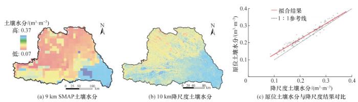
表 2 SMAP土壤水分及降尺度产品与原位数据验证结果比较
时间 被验证数据 R2 RMSE/(m3·m-3)
2019-08-08 SMAP土壤水分 0.67 0.032
降尺度土壤水分 0.79 0.028
2020-07-23 SMAP土壤水分 0.73 0.056
降尺度土壤水分 0.80 0.044

2.4 基于土壤水分的河流表面信息提取

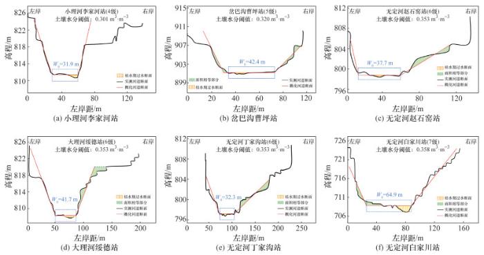
GRF-CNN提取得到无定河流域枯水期河流表面信息精度为90.3%,结果包括枯水期河流过水表面信息和基于消落带土壤水分特征提取的湿润河床(图 9)。本研究统计得到无定河流域主要水文站2012—2020年平均实测大断面(图 10),并基于大断面数据分析提取结果误差。为准确获取床面范围,设定土壤水分阈值确定每级河流床面提取边界。定义边坡线与水平面夹角为α,基于水文站实测大断面及提取床面计算考虑土壤水分阈值前后的边坡角。研究得到各级别河流提取土壤水分阈值见表 3,其中更高级别的河流(级别4~7)对应提取土壤水分阈值也更大。提取结果与实测大断面的面积误差为3.5%,较原算法提升27.3%。基于该提取结果计算的边坡斜率与概化断面拟合效果更优。
图 9 GRF-CNN枯水期河流表面信息提取结果
图 10 无定河流域断面概化结果示意
表 3 全流域不同级别河流表面信息提取阈值设置与调整前后坡岸均值对比
河流级别 断面形态 土壤水分阈值/ (m3·m-3) 调整前边坡角α/ (°) 调整后边坡角β/ (°) 过水断面面积变化/%
7 梯形 0.366 17.27 34.32 +23.1
6 0.358 18.16 43.98 +26.4
5 0.353 17.90 26.33 +30.2
4 0.320 18.05 23.15 +31.3
基于给定的土壤水分阈值,利用GRF-CNN提取无定河流域256个采样点的河流表面信息,采用ArcGIS“字段计算器”工具[57]测量实验点位河宽,与Google Earth对应的枯水期影像对比结果见图 11表 4给出了本方法与RF和PRF-ANN方法的提取结果对比,基于采样点河宽信息,本研究提取床面河宽与Google Earth测量结果的R2、RMSE分别为0.86、1.32 m,相对误差为6.7%,显著低于改进前的21.4%。总体来看,GRF-CNN算法显著提升了枯水期河流床面河宽提取精度。
图 11 GRF-CNN提取床面宽度精度评价
表 4 各模型床面河宽提取结果与Google Earth测量结果对比
提取模型 R2 RMSE/m
RF 0.36 4.52
PRF-ANN 0.67 2.36
GRF-CNN(本文方法) 0.89 1.32

2.5 不同机器学习算法测试结果对比

本研究设计实验对比了GRF-CNN模型与现有受认可度较高的遥感影像分类模型(DiCNN-4、Bi-LSTM、Transformer)[58-60]的提取效果。DiCNN-4是基于对象的图像分类框架的卷积神经网络算法,在大型数据集的实验结果优于其他CNN模型[58],实验算法设定步长为1,选取ReLU函数作为激活函数,构建卷积网络。Bi-LSTM是长短期记忆(long short-term memory,LSTM)网络的改进算法,它们同时向前和向后处理输入序列[59],实验算法的时间步长设置为10,选取循环次数为257次。测试的Transformer选取TSTNet架构,模型直接用于图像序列完成图像分类任务[60]图 12展示了4种模型在5个性能指标(Kappa系数、整体精度、分类精度、F1值和召回率)上的表现。GRF-CNN模型在大多数性能指标上的表现优于其他模型,提取的枯水期结果能更好地表征河流床面。对于提取难度大的间歇性细小河流, 基于相同数据源将本研究方法与现有受认可度较高的算法进行对比,结果显示GRF-CNN提取结果完整度更高,抗地物干扰能力更强。
图 12 GRF-CNN与其他深度学习模型提取结果对比
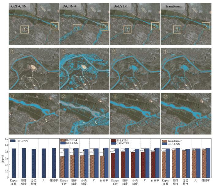
GRF-CNN耦合多尺度奇点指数、热红外数据降尺度反演及土壤水分降尺度数据,因而提取结果是更符合河流几何特征的床面信息。常规遥感影像深度学习分类算法对于河流特征的考虑较少[61],而更多关注水体本身波段反射的物理机制,因此识别得到的结果较差。GRF-CNN算法耦合土壤水分降尺度结果,优化了河流床面信息的提取效果。

3 总结

本研究以平滩期和枯水期多源遥感影像为数据源,基于GRF-CNN算法提取了无定河流域平滩期河流表面及枯水期床面信息,并给出了不同级别河流枯水期床面提取的土壤水分阈值,对比分析了GRF-CNN算法与其他深度学习算法的河流提取效果。得出如下主要结论:
1) 建立了土壤水分降尺度反演方法,利用DSNN表征学习神经网络,提升了被动微波土壤水分数据的空间分辨率。原位土壤水分与降尺度结果的R2为0.81,误差介于0.026~0.059 m3/m3
2) 基于GRF-CNN算法提取了无定河流域河流表面信息。提取平滩表面结果Kappa系数为0.93,精度为95.7%,得到枯水期断面面积与实测大断面误差为3.5%。对比其他基于深度学习的水体识别算法,精度至少提升了10.3%。
3) 本研究首次将土壤水分与热红外数据降尺度反演相结合,为枯水期河流床面信息提取提供了新的思路。本研究结果不仅为大尺度流域的河流边界重构提供了关键参数,也为缺资料地区数字孪生流域建设提供了技术支撑。
当前河流表面信息提取的研究,既存在对国外产品的严重依赖,又面临着提升提取能力和效率的挑战[62]。未来,将进一步引入更多类型数据(如雷达数据、激光雷达数据等),提供更丰富的地表信息。在算法层面进一步优化多源数据之间的异构性和时间差异,提升数据融合和处理的效率及准确性。
1
ECHEVERRIBAR I , MORALES-HERNÁNDEZ M , BRUFAU P , et al. Use of internal boundary conditions for levees representation: Application to river flood management[J]. Environmental Fluid Mechanics, 2019, 19 (5): 1253- 1271.

2
SCHÄPPI B , PERONA P , SCHNEIDER P , et al. Integrating river cross section measurements with digital terrain models for improved flow modelling applications[J]. Computers & Geosciences, 2010, 36 (6): 707- 716.

3
GU P F , LIAO A M , LIU H W , et al. River cross-section measurement using unreviewed aerial vehicle with an improved bathymetry instrument[J]. Journal of Hydrology, 2023, 624, 129737.

4
MA H B , NITTROUER J A , FU X D , et al. Amplification of downstream flood stage due to damming of fine-grained rivers[J]. Nature Communications, 2022, 13 (1): 3054.

5
GICHAMO T Z , POPESCU I , JONOSKI A , et al. River cross-section extraction from the ASTER global DEM for flood modeling[J]. Environmental Modelling & Software, 2012, 31, 37- 46.

6
李超然, 苗令占, 侯俊. 间歇性河流中生物膜对干湿胁迫的动态响应[J]. 中国环境科学, 2021, 41 (11): 5245- 5253.

DOI

LI C R , MIAO L Z , HOU J . Dynamic response of biofilm to dry and wet stress in intermittent rivers[J]. China Environmental Science, 2021, 41 (11): 5245- 5253.

DOI

7
SHANAFIELD M , BLANCHETTE M , DALY E , et al. Australian non-perennial rivers: Global lessons and research opportunities[J]. Journal of Hydrology, 2024, 634, 130939.

8
CHEN H L , LIANG Q H , LIANG Z Y , et al. Extraction of connected river networks from multi-temporal remote sensing imagery using a path tracking technique[J]. Remote Sensing of Environment, 2020, 246, 111868.

9
王平. 西北干旱区间歇性河流与含水层水量交换研究进展与展望[J]. 地理科学进展, 2018, 37 (2): 183- 197.

WANG P . Progress and prospect of research on water exchange between intermittent rivers and aquifers in arid regions of northwestern China[J]. Progress in Geography, 2018, 37 (2): 183- 197.

10
MESSAGER M L , LEHNER B , COCKBURN C , et al. Global prevalence of non-perennial rivers and streams[J]. Nature, 2021, 594 (7863): 391- 397.

11
李德仁, 王密, 沈欣, 等. 从对地观测卫星到对地观测脑[J]. 武汉大学学报(信息科学版), 2017, 42 (2): 143- 149.

LI D R , WANG M , SHEN X , et al. From earth observation satellite to earth observation brain[J]. Geomatics and Information Science of Wuhan University, 2017, 42 (2): 143- 149.

12
WANG R H , ZHANG S W , PU L M , et al. Gully erosion mapping and monitoring at multiple scales based on multi-source remote sensing data of the Sancha River Catchment, Northeast China[J]. ISPRS International Journal of Geo-Information, 2016, 5 (11): 200.

13
XU J , WANG L , YAO T D , et al. Totaling river discharge of the third pole from satellite imagery[J]. Remote Sensing of Environment, 2024, 308, 114181.

14
ABBASPOUR K C , ROUHOLAHNEJAD E , VAGHEFI S , et al. A continental-scale hydrology and water quality model for Europe: Calibration and uncertainty of a high-resolution large-scale SWAT model[J]. Journal of Hydrology, 2015, 524, 733- 752.

15
CHEN X , LONG D , HONG Y , et al. Improved modeling of snow and glacier melting by a progressive two-stage calibration strategy with GRACE and multisource data: How snow and glacier meltwater contributes to the runoff of the Upper Brahmaputra River Basin?[J]. Water Resources Research, 2017, 53 (3): 2431- 2466.

16
薛源, 覃超, 吴保生, 等. 基于多源遥感数据的黄河数字流域模型改进[J]. 水利学报, 2023, 54 (8): 930- 941.

XUE Y , QIN C , WU B S , et al. Improvement of the Digital Yellow River Integrated Model based on multisource remote sensing[J]. Journal of Hydraulic Engineering, 2023, 54 (8): 930- 941.

17
RAHAMAN M H , ROSHANI , MASROOR M , et al. Integrating remote sensing derived indices and machine learning algorithms for precise extraction of small surface water bodies in the lower Thoubal River Watershed, India[J]. Journal of Cleaner Production, 2023, 422, 138563.

18
ILYUSHIN Y V , NOSOVA V A . Methodology to increase the efficiency of the mineral water extraction process[J]. Water, 2024, 16 (10): 1329.

19
SEATON D , DUBE T , MAZVIMAVI D . Use of multi-temporal satellite data for monitoring pool surface areas occurring in non-perennial rivers in semi-arid environments of the Western Cape, South Africa[J]. ISPRS Journal of Photogrammetry and Remote Sensing, 2020, 167, 375- 384.

20
陈新, 徐国策, 李清顺, 等. 大理河消落带土壤微生物群落功能多样性[J]. 水土保持研究, 2023, 30 (5): 193- 200.

CHEN X , XU G C , LI Q S , et al. Functional diversity of soil microbial communities in the water-level-fluctuating zone of Dali River[J]. Research of Soil and Water Conservation, 2023, 30 (5): 193- 200.

21
SINGH A , GAURAV K , SONKAR G K , et al. Strategies to measure soil moisture using traditional methods, automated sensors, remote sensing, and machine learning techniques: Review, bibliometric analysis, applications, research findings, and future directions[J]. IEEE Access, 2023, 11, 13605- 13635.

22
赵伟, 文凤平, 蔡俊飞. 被动微波土壤水分遥感产品空间降尺度研究: 方法、进展及挑战[J]. 遥感学报, 2022, 26 (9): 1699- 1722.

ZHAO W , WEN F P , CAI J F . Methods, progresses, and challenges of passive microwave soil moisture spatial downscaling[J]. National Remote Sensing Bulletin, 2022, 26 (9): 1699- 1722.

23
XUE Y , QIN C , WU B S , et al. Simulation of runoff process based on the 3-D river network[J]. Journal of Hydrology, 2023, 626, 130192.

24
WANG M , WANG L , GUO Y , et al. A comprehensive evaluation of dual-polarimetric Sentinel-1 SAR data for monitoring key phenological stages of winter wheat[J]. Remote Sensing, 2024, 16 (10): 1659.

25
LIAO Y J , WU G R , ZHANG Z Y . Multi-scale remote sensing assessment of ecological environment quality and its driving factors in watersheds: A case study of Huashan Creek Watershed in China[J]. Remote Sensing, 2023, 15 (24): 5633.

26
KATTENBORN T , LEITLOFF J , SCHIEFER F , et al. Review on convolutional neural networks (CNN) in vegetation remote sensing[J]. ISPRS Journal of Photogrammetry and Remote Sensing, 2021, 173, 24- 49.

27
PAN H. Cloud removal for remote sensing imagery via spatial attention generative adversarial network[Z]. arXiv: 2009.13015, 2020.

28
文凤平, 赵伟, 胡路, 等. 耦合MODIS数据的SMAP被动微波土壤水分空间降尺度研究: 以闪电河流域为例[J]. 遥感学报, 2021, 25 (4): 962- 973.

WEN F P , ZHAO W , HU L , et al. SMAP passive microwave soil moisture spatial downscaling based on optical remote sensing data: A case study in Shandian River Basin[J]. National Remote Sensing Bulletin, 2021, 25 (4): 962- 973.

29
CHAN S K , BINDLISH R , O'NEILL P E , et al. Assessment of the SMAP passive soil moisture product[J]. IEEE Transactions on Geoscience & Remote Sensing, 2016, 54 (8): 4994- 5007.

30
TORRES R, GEUDTNER D, LOKAS S, et al. Sentinel-1 satellite evolution[C]// 2018 IEEE International Geoscience and Remote Sensing Symposium. Valencia, Spain: IEEE, 2018: 1555-1558.

31
BAGHDADI N , EL HAJJ M , ZRIBI M , et al. Calibration of the water cloud model at C-band for winter crop fields and grasslands[J]. Remote Sensing, 2017, 9 (9): 969.

32
DUBOIS P C , VAN ZYL J , ENGMAN T . Measuring soil moisture with imaging radars[J]. IEEE Transactions on Geoscience and Remote Sensing, 1995, 33 (4): 915- 926.

33
CHEN L , SHI J C , WIGNERON J P , et al. A parameterized surface emission model at L-band for soil moisture retrieval[J]. IEEE Geoscience and Remote Sensing Letters, 2010, 7 (1): 127- 130.

34
CHEN Y H , CHEN S W , JIAN H W , et al. A very large-scale integration (VLSI) chip design for abnormal heartbeat detection using a data-shifting neural network (DSNN)[J]. IEEE Access, 2024, 12, 14005- 14013.

35
LI Y W , XU T H , YANG S Q , et al. A forward model and inversion algorithm for near-surface soil moisture estimation with GNSS refraction pattern technique[J]. IEEE Transactions on Geoscience and Remote Sensing, 2024, 62, 4301119.

36
JEONG J , TSANG L , XU X L , et al. Full-wave electromagnetic model simulations of P-band radio signal propagation through forest using the fast hybrid method[J]. IEEE Journal of Selected Topics in Applied Earth Observations and Remote Sensing, 2023, 16, 6711- 6722.

37
SINGH S K , PRASAD R , SRIVASTAVA P K , et al. Incorporation of first-order backscattered power in water cloud model for improving the leaf area index and soil moisture retrieval using dual-polarized Sentinel-1 SAR data[J]. Remote Sensing of Environment, 2023, 296, 113756.

38
SETTU P , RAMAIAH M . Estimation of Sentinel-1 derived soil moisture using modified Dubois model[J]. Environment, Development and Sustainability, 2024, 26 (11): 29677- 29693.

39
WANG Z H , YANG Y , ZENG J Y , et al. Surface parameter bias disturbance in radar backscattering from bare soil surfaces[J]. IEEE Transactions on Geoscience and Remote Sensing, 2024, 62, 2005917.

40
RAINES E , JOHNSON J T . A study of the Kirchhoff approximation for the coherent reflection coefficient of a 1-D perfectly conducting rough surface[J]. IEEE Geoscience and Remote Sensing Letters, 2024, 21, 4500104.

41
LIU J C , HUANG G H , SONG T , et al. Stepwise clustering ensemble downscaling for future drought prediction under climate change: A case study of the Yangtze River Basin[J]. Journal of Hydrology, 2024, 633, 131005.

42
许炯心. 无定河流域侵蚀产沙过程对水土保持措施的响应[J]. 地理学报, 2004, 59 (6): 972- 981.

DOI

XU J X . Response of erosion and sediment producing processes to soil and water conservation measures in the Wudinghe River Basin[J]. Acta Geographica Sinica, 2004, 59 (6): 972- 981.

DOI

43
李刚, 潘保柱, 丁一桐, 等. 无定河流域浮游动物群落结构特征及水质生物评价[J]. 中国环境监测, 2024, 40 (3): 181- 196.

LI G , PAN B Z , DING Y T , et al. Characteristics of zooplankton community structure and bioassessment of water quality in the Wuding River Basin[J]. Environmental Monitoring in China, 2024, 40 (3): 181- 196.

44
张小瑜, 周自翔, 唐志雄, 等. 无定河流域生境质量时空变化及预测[J]. 中国沙漠, 2024, 44 (3): 75- 84.

ZHANG X Y , ZHOU Z X , TANG Z X , et al. Spatio-temporal variation and prediction of habitat quality in Wuding River Basin[J]. Journal of Desert Research, 2024, 44 (3): 75- 84.

45
GAO S X, HE B B, GUAN Y W, et al. Study on theoretical reserves of water energy and its distribution based on HYDRO30 digital drainage network[C]// 2018 IEEE International Geoscience and Remote Sensing Symposium. Valencia, Spain: IEEE, 2018: 749-752.

46
农晓星, 聂卫波, 马孝义. 无定河流域风沙滩区河道基流变化规律与驱动因素分析[J]. 水土保持学报, 2023, 37 (1): 103- 113.

NONG X X , NIE W B , MA X Y . Baseflow variation and driving factors in the blown-sand region of Wuding River Basin[J]. Journal of Soil and Water Conservation, 2023, 37 (1): 103- 113.

47
覃超, 吴保生, 汪舸, 等. 青藏高原山区河流广义河相关系与多频率沿程河相关系[J]. 水利学报, 2022, 53 (2): 176- 187.

QIN C , WU B S , WANG G , et al. Generalized hydraulic geometry and multi-frequency downstream hydraulic geometry of mountain rivers originated from the Qinghai-Tibet Plateau[J]. Journal of Hydraulic Engineering, 2022, 53 (2): 176- 187.

48
GARBA H , UDOKPOH U U . Analysis of trend in meteorological and hydrological time-series using Mann-Kendall and Sen's slope estimator statistical test in Akwa Ibom state, Nigeria[J]. International Journal of Environment and Climate Change, 2023, 13 (10): 1017- 1035.

49
夏军强, 吴保生, 李文文. 黄河下游平滩流量不同确定方法的比较[J]. 泥沙研究, 2009 (3): 20- 29.

DOI

XIA J Q , WU B S , LI W W . Comparison of different approaches to determine bankfull discharge in the lower Yellow River[J]. Journal of Sediment Research, 2009 (3): 20- 29.

DOI

50
刘然, 徐国策, 李占斌, 等. 陕西大理河流域枯水期土地利用结构对河流水质的影响[J]. 地球科学与环境学报, 2022, 44 (2): 327- 337.

LIU R , XU G C , LI Z B , et al. Impact of land use structure on river water quality during dry season in Dali River Basin of Shaanxi, China[J]. Journal of Earth Sciences and Environment, 2022, 44 (2): 327- 337.

51
OUYANG W , SHAN Y S , HAO F H , et al. Accumulated impact assessment of river buffer zone after 30 years of dam disturbance in the Yellow River Basin[J]. Stochastic Environmental Research and Risk Assessment, 2013, 27 (5): 1069- 1079.

52
VENTER Z S , BARTON D N , CHAKRABORTY T , et al. Global 10 m land use land cover datasets: A comparison of dynamic world, world cover and Esri land cover[J]. Remote Sensing, 2022, 14 (16): 4101.

53
LI Z H , HE W , CHENG M F , et al. SinoLC-1: The first 1 m resolution national-scale land-cover map of China created with a deep learning framework and open-access data[J]. Earth System Science Data, 2023, 15 (11): 4749- 4780.

54
NICLÒS R , PERELLÓ M , PUCHADES J , et al. Evaluating Landsat-9 TIRS-2 calibrations and land surface temperature retrievals against ground measurements using multi- instrument spatial and temporal sampling along transects[J]. International Journal of Applied Earth Observation and Geoinformation, 2023, 125, 103576.

55
PEKEL J F , COTTAM A , GORELICK N , et al. High- resolution mapping of global surface water and its long-term changes[J]. Nature, 2016, 540 (7633): 418- 422.

56
LI Z L , ZENG Z F , XIONG H Q , et al. Study on rapid inversion of soil water content from ground-penetrating radar data based on deep learning[J]. Remote Sensing, 2023, 15 (7): 1906.

57
ELSONBATY L , EL-DIN FAWZY H , MOGHAZY H M , et al. Vertical accuracy assessment for open-source digital elevation models using GPS control points and watershed basins delineation using GIS[J]. Alexandria Engineering Journal, 2023, 84, 47- 58.

58
ZHANG X D , WANG Q , CHEN G Z , et al. An object-based supervised classification framework for very-high-resolution remote sensing images using convolutional neural networks[J]. Remote Sensing Letters, 2018, 9 (4): 373- 382.

59
SHAHID F , ZAMEER A , MUNEEB M . Predictions for COVID-19 with deep learning models of LSTM, GRU and Bi-LSTM[J]. Chaos, Solitons and Fractals, 2020, 140, 110212.

60
SONG X Z, WU Y, ZHANG C H. TSTNet: A sequence to sequence transformer network for spatial-temporal traffic prediction[C]// 30th International Conference on Artificial Neural Networks. Bratislava, Slovakia: Springer, 2021: 343-354.

61
冯思维, 杨清华, 贾伟洁, 等. 基于光学遥感的内陆地表水体提取综述[J]. 自然资源遥感, 2024, 36 (3): 41- 56.

FENG S W , YANG Q H , JIA W J , et al. Information extraction of inland surface water bodies based on optical remote sensing: A review[J]. Remote Sensing for Natural Resources, 2024, 36 (3): 41- 56.

62
NAGARAJ R , KUMAR L S . Extraction of surface water bodies using optical remote sensing images: A review[J]. Earth Science Informatics, 2024, 17 (2): 893- 956.

Outlines

/